The outstanding intersection of 7.3m at 4.2% Cu reveals a potential new lode ~250m from the main deposit; Follow-up downhole EM identifies a large off-hole conductor; Two diamond drill rigs currently on site
HIGHLIGHTS:
- High-grade result of 7.3m @ 4.2% Cu, 0.3g/t Au & 16.6g/t Ag from 317.8m
- Including 2.5m @ 9.1% Cu, 0.5g/t Au & 31.4g/t Ag
- The result reveals a potential new lode ~250m from Corner Bay, which is the primary deposit at the Chibougamau Project; Corner Bay has Indicated Mineral Resources of 2.7Mt at 2.7% Cu & 0.3g/t Au and Inferred Mineral Resources of 5.9Mt at 3.4% Cu & 0.3g/t Au 1
- The recent intersection is associated with a significant off hole electromagnetic anomaly (530m x 460m) which has not yet been drilled
- The result highlights the potential for multiple sub-parallel lodes at Corner Bay analogous to other well-known deposits in the region; two diamond rigs are on site across both Corner Bay and other drilling targets with further results anticipated this half
- The Chibougamau district is a world class mineral terrane with high potential for additional discovery, having historically produced over 945,000t of copper and 3.5Moz of gold 2
- The Project has excellent infrastructure with a 900,000tpa processing facility, local mining town, sealed highway, airport, regional rail infrastructure and 25kV hydro power to the processing site
| Cygnus Executive Chairman, David Southam said : ‘We are delighted to hit the ground running with an excellent intersection from a previously undrilled area which is only 250m away from main Corner Bay Deposit.
‘This result supports our view that there is much more to find at Chibougamau, both near the existing deposits and in the wider region, and is consistent with our strategy to create shareholder value by growing the resource.
‘The downhole geophysics is already proving to be a key tool for the project and will help us unlock other under-explored areas of the project’.
|
1 The Mineral Resource Estimate at the Chibougamau Project is a foreign estimate prepared in accordance with CIM Standards. A competent person has not done sufficient work to classify the foreign estimate as a mineral resource in accordance with the JORC Code, and it is uncertain whether further evaluation and exploration will result in an estimate reportable under the JORC Code.
Cygnus Metals Limited (ASX: CY5; TSXV: CYG) (‘Cygnus’ or the ‘Company’) is pleased to announce that it has made an outstanding start to its exploration campaign at the Chibougamau Copper-Gold Project in Quebec, Canada, with the first hole returning assays of up to 2.5m @ 9.1% Copper .
Prior to the merger of Cygnus and Doré Copper Mining Corp. closing, both teams executed a targeted exploration program to test the immediate areas around the Corner Bay deposit, looking for both additional structures and extensions to the current resource.
The first drillhole from this program has returned an intersection of 7.3m @ 4.2% Cu, 0.3g/t Au & 16.6g/t Ag, including 2.5m @ 9.1% Cu, 0.5g/t Au & 31.4g/t Ag from a potential new lode ~250m east of the existing resource in the footwall of the Corner Bay deposit. Follow up downhole electromagnetics has since defined a significant off hole electromagnetic anomaly (530m x 460m) to the north and down dip of the intersection that has yet to be tested by drilling.
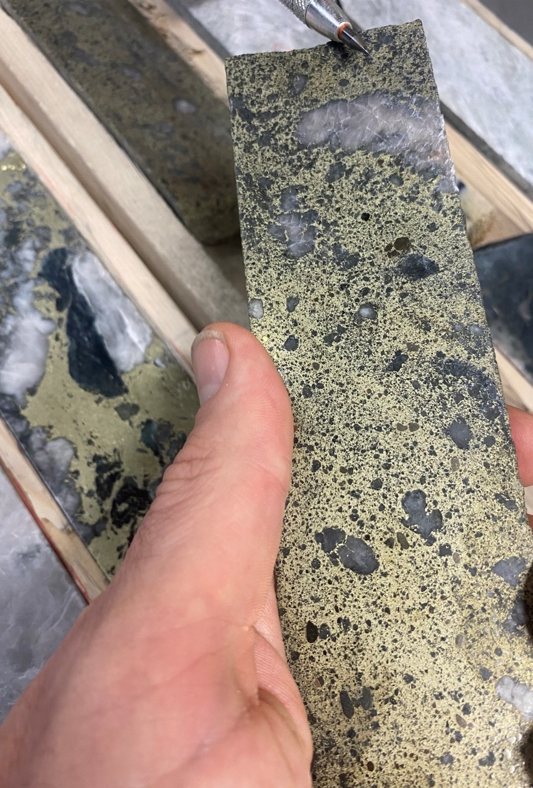
Image 1: High grade drill core from CB-24-100 intersecting 7.3m @ @ 4.2% Cu, 0.3g/t Au & 16.6g/t Ag.
Image showing core between 321.9m and 322.6m.
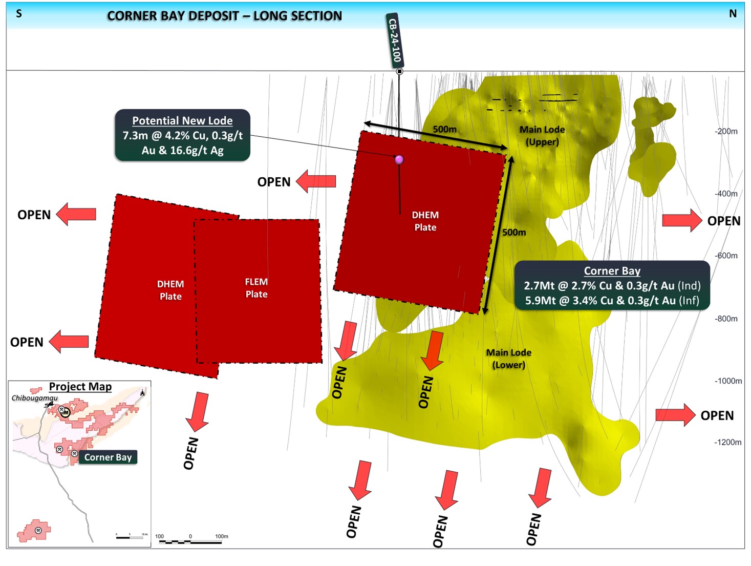
Figure 1: Long section of the Corner Bay deposit with potential new lode in the footwall of the main deposit. Large 530mx460m untested EM plate along with further untested EM plates to the south.
About the Drilling and Geophysical Results
The first hole of the program (CB-24-100) targeting the footwall of the Corner Bay deposit has intersected a potential new sub parallel lode with a high-grade drill result of 7.3m @ 4.2% Cu, 0.3g/t Au & 16.6g/t Ag from 317.8m, which includes 2.5m @ 9.1% Cu, 0.5g/t Au & 31.4g/t Ag .
The result highlights the potential for multiple sub-parallel lodes at the Corner Bay deposit analogous to other well-known deposits in the region. This new structure sits 250m to the east of the Main Lode at Corner Bay in an area with very little drilling. This presents an exciting target for follow up drilling and an opportunity to add to the existing resources at Corner Bay.
In addition, follow up electromagnetics (‘EM’) completed on the recent drilling has defined a large (530m x 460m) conductive plate offset to the north and down dip of drillhole CB-24-100. EM is known to correspond well with the mineralisation style at the Chibougamau mining camp, being primarily composed of chalcopyrite with minor amounts of pyrite and pyrrhotite. Historically, airborne EM has been used to make some of the discoveries in the region, although ground and downhole EM has been underutilised in more recent times. The large EM plate provides a priority target for follow up exploration along this structure.
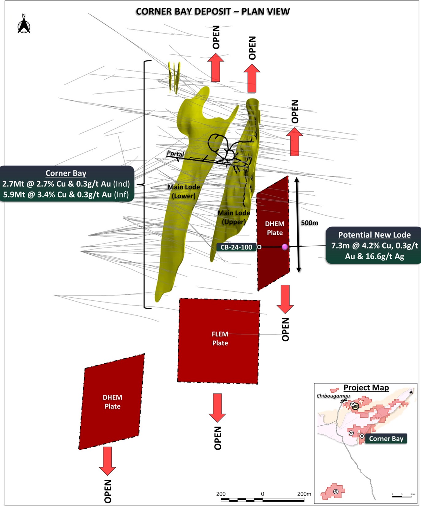
Figure 2: Plan view of the Corner Bay deposit with potential new lode to the east of the Main Lode at Corner Bay. Also illustrating other untested EM plates.
Ongoing Drilling
In line with the Company’s resource growth strategy, drilling is underway with two diamond drill rigs. This initial program will focus on resource growth opportunities surrounding some of the existing deposits aiming to build upon the existing high-grade resources. The Company looks forward to a high volume of news flow during 2025 with ongoing drilling updates and results.
About the Corner Bay Deposit
Cygnus’ flagship Corner Bay deposit within the Chibougamau Project is located 17km (straight line) south of the Chibougamau processing facility. The deposit was discovered in the 1980s and has never been mined although ramp access was established to 115m for the purpose of initial bulk sampling test work.
The deposit is the primary resource in the combined Project resources, making up 79% of the total resource with Indicated Mineral Resources of 2.7Mt @ 2.7% Cu & 0.3g/t Au and Inferred Mineral Resources of 5.9Mt @ 3.4% Cu and 0.3g/t Au. 1
Mineralisation extends from surface and has been defined over 1,000m of strike and to a depth of 1,350m with mineralisation remaining open in all directions. The mineralisation is structurally controlled and hosted as a north-south striking quartz-carbonate vein with semi massive chalcopyrite and minor pyrite mineralisation. The main lode has been crosscut and offset by a large diabase dyke with an upper and lower portion of the lode positioned either side of the dyke.
The Corner Bay deposit sits on the southern flank of the Chibougamau pluton and has seen minimal exploration compared to the north. The northern flank is host to 16 mined deposits and has contributed a significant portion of the regions historic production ~945,000t of copper and 3.5Moz of gold. 2 Corner Bay in the south shares comparable lithological and structural characteristics to the northern deposits, however, as the northern mines developed, multiple sub-parallel lodes were subsequently discovered within the same structural corridor. Due to the relatively early stage of defining the Corner Bay deposit, potential parallel lodes and resource extension have not yet been properly explored and the latest intersection highlights the potential for additional sub-parallel lodes within the immediate vicinity of the current resources.
About the Chibougamau Copper-Gold Project
The Chibougamau copper-gold project (‘Chibougamau Project’) is located in central Quebec, Canada approximately 480km due north of Montreal. The province of Quebec has been recognised as a top ten global mining investment jurisdiction in the 2023 Fraser Institute Annual Survey of Mining Companies. The project has excellent infrastructure with a local mining town, sealed highway, airport, regional rail infrastructure and access to hydro power via installed powerlines.
The Chibougamau Project is centred on the Chibougamau pluton with a district wide historic production of 53.5Mt @ 1.8% Cu and 2.1g/t Au 2 with periodic mining between the early 1900s and 2008. Over this long mining history, the district has produced over 945,000t of copper and 3.5Moz of gold from 16 former producing mines. 2
The Chibougamau Project has high-grade resources including a Measured and Indicated Mineral Resources of 3.6Mt at 2.5% Cu & 0.6g/t Au and Inferred Mineral Resources of 7.2Mt at 3.0% Cu & 1.1g/t Au with significant potential to grow. 1
The Company has a clear strategy to:
- Rapidly grow the resource through brownfield exploration and investment in drilling; and
- Advance the project towards development through study work and utilising existing infrastructure.
The Company sees a huge opportunity to create shareholder value by an established high-grade resource with opportunity for growth, excellent infrastructure, 900ktpa processing facility and clear pathway to production, all within a quality endowed mineral terrane that has seen minimal modern exploration.
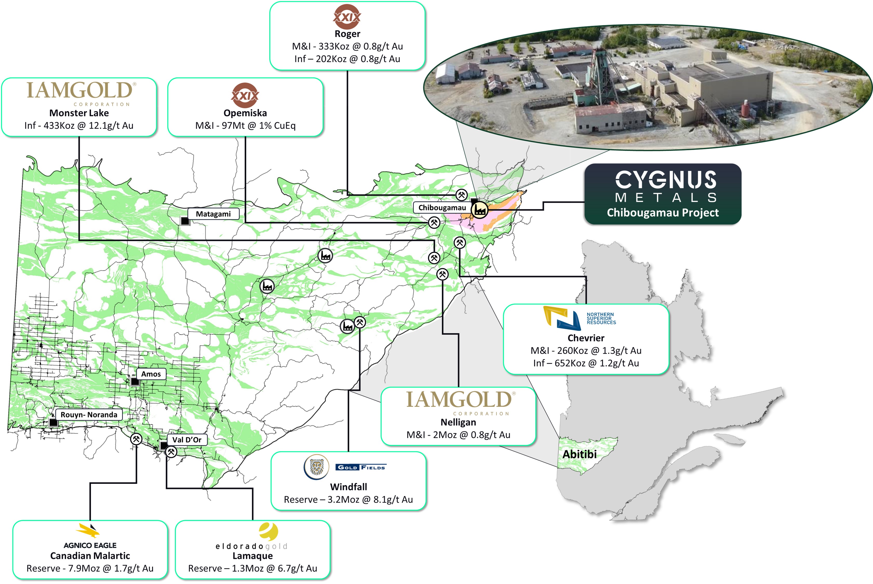
Figure 3: Location of the Chibougamau Project relative to other major deposits and processing facilities. 3
This announcement has been authorised for release by the Board of Directors of Cygnus.
David Southam
Executive Chair
T: +61 8 6118 1627
E: info@cygnusmetals.com |
Ernest Mast
President & Managing Director
T: +1 647 921 0501
E: info@cygnusmetals.com |
Media:
Paul Armstrong
Read Corporate
T: +61 8 9388 1474 |
|
|
|
About Cygnus Metals
Cygnus Metals Limited (ASX: CY5, TSXV: CYG) is a diversified critical minerals exploration and development company with projects in Quebec, Canada and Western Australia. The Company is dedicated to advancing its Chibougamau Copper-Gold Project in Quebec with an aggressive exploration program to drive resource growth and develop a hub-and-spoke operation model with its centralised processing facility. In addition, Cygnus has quality lithium assets with significant exploration upside in the world-class James Bay district in Quebec, and REE and base metal projects in Western Australia. The Cygnus team has a proven track record of turning exploration success into production enterprises and creating shareholder value.
Forward Looking Statements
This document contains ‘forward-looking information’ and ‘forward-looking statements’ which are based on the assumptions, estimates, analysis and opinions of management made in light of its experience and its perception of trends, current conditions and expected developments, as well as other factors that management of Cygnus believes to be relevant and reasonable in the circumstances at the date that such statements are made, but which may prove to be incorrect. Forward-looking statements include statements that are predictive in nature, depend upon or refer to future events or conditions, or include words such as ‘expects’, ‘anticipates’, ‘plans’, ‘believes’, ‘estimates’, ‘seeks’, ‘intends’, ‘targets’, ‘projects’, ‘forecasts’, or negative versions thereof and other similar expressions, or future or conditional verbs such as ‘may’, ‘will’, ‘should’, ‘would’ and ‘could’. Although Cygnus and its management believe that the assumptions and expectations represented by such information are reasonable, there can be no assurance that the forward-looking information will prove to be accurate. Forward-looking information involves known and unknown risks, uncertainties, and other factors which may cause the actual results, performance or achievements of Cygnus to be materially different from any anticipated future results, performance or achievements expressed or implied by such forward-looking information. Such factors include, among others, the actual results of current or future exploration, changes in project parameters as plans continue to be evaluated, changes in laws, regulations and practices, the geopolitical, economic, permitting and legal climate that Cygnus operates in, as well as those factors disclosed in Cygnus’ publicly filed documents. No representation or warranty is made as to the accuracy, completeness or reliability of the information, and readers should not place undue reliance on forward-looking information or rely on this document as a recommendation or forecast by Cygnus. Cygnus does not undertake to update any forward-looking information, except in accordance with applicable securities laws.
End Notes
- The Mineral Resource estimate at the Chibougamau Project is a foreign estimate prepared in accordance with CIM Standards. A competent person has not done sufficient work to classify the foreign estimate as a mineral resource in accordance with the JORC Code, and it is uncertain whether further evaluation and exploration will result in an estimate reportable under the JORC Code. Refer to Appendix A for a breakdown of the Mineral Resource Estimate.
- Sources for historic production figures: Economic Geology, v. 107, pp. 963–989 – Structural and Stratigraphic Controls on Magmatic, Volcanogenic, and Shear Zone-Hosted Mineralization in the Chapais-Chibougamau Mining Camp, Northeastern Abitibi, Canada by François Leclerc et al. (Lac Dore/Chibougamau mining camp).
- For regional Mineral Reserves and Resources in Quebec listed in Fig. 3: (a) at Monster Lake and Nelligan as of 31 December 2023, refer to IAMGOLD Corporation’s news release dated 15 February 2024; (b) at Windfall, refer to Osisko Mining’s NI 43-101 Technical Report filed with SEDAR on 10 January 2023; (c) at Lamaque Complex as of 30 September 2024, refer to Eldorado Gold’s news release dated 11 December 2024 (d) at Canadian Malartic Complex as of 30 September 2024, refer to Agnico Eagle’s news release dated 15 February 2024; (e) at Opemiska, refer to XXIX’s news release dated 8 January 2024; (f) at Roger, refer to the SOQUEM and Enforcer Gold Corp’s NI 43-101 Technical Report dated 9 October 2018; and (g) at Chevrier, refer to Northern Superior Resources’s news release dated 24 January 2022.
Qualified Persons and Compliance Statements
The scientific and technical information in this news release has been reviewed and approved by Mr Louis Beaupre, the Quebec Exploration Manager of Cygnus, a ‘qualified person’ as defined in National Instrument 43-101 – Standards of Disclosure for Mineral Projects. The Exploration Results disclosed in this announcement are also based on and fairly represent information and supporting documentation compiled by Mr Beaupre. Mr Beaupre holds options in Cygnus. Mr Beaupre is a member of the Ordre des ingenieurs du Quebec (P Eng), a Registered Overseas Professional Organisation as defined in the ASX Listing Rules, and has sufficient experience which is relevant to the style of mineralisation and type of deposits under consideration and to the activity which has been undertaken to qualify as a Competent Person as defined in the 2012 Edition of the ‘Australasian Code for Reporting of Exploration Results, Mineral Resources and Ore Reserves’. Mr Beaupre consents to the inclusion in this release of the matters based on the information in the form and context in which they appear.
The Company first announced the foreign estimate of mineralisation for the Chibougamau Project on 15 October 2024. The Company confirms that the supporting information included in the original announcement continues to apply and has not materially changed. Cygnus confirms that it is not aware of any new information or data that materially affects the information included in the original announcement and that all material assumptions and technical parameters underpinning the estimates in the original announcement continue to apply and have not materially changed. Cygnus confirms that its is not in possession of any new information or data that materially impacts on the reliability of the estimates or Cygnus’ ability to verify the foreign estimates as mineral resources in accordance with the JORC Code. The Company confirms that the form and context in which the Competent Persons’ findings are presented have not been materially modified from the original market announcement.
Neither TSX Venture Exchange nor its Regulation Services Provider (as that term is defined in policies of the TSX Venture Exchange) accepts responsibility for the adequacy or accuracy of this release.
APPENDIX A – Significant Intersections
Coordinates given in UTM NAD83 (Zone 18). Intercept lengths may not add up due to rounding to the appropriate reporting precision . Significant intersections reported above 0.5% copper or 0.5g/t gold over widths of greater than 1m containing a maximum of 3m internal waste. The true width is estimated at approximately 75% of the downhole width.
| Hole ID |
X |
Y |
Z |
Azi |
Dip |
Depth |
From |
to |
Interval |
Cu % |
Au g/t |
Ag g/t |
Mo ppm |
| CB-24-100 |
555047 |
5509802 |
400 |
90 |
-65 |
498.0 |
317.1 |
324.4 |
7.3 |
4.2 |
0.3 |
16.6 |
170 |
|
|
|
|
|
Including |
321.9 |
324.4 |
2.5 |
9.1 |
0.5 |
31.4 |
183 |
APPENDIX B – Chibougamau Copper-Gold Project – Foreign Mineral Resource Estimate Disclosures as at 30 March 2022
| Deposit |
Category |
Tonnes
(k) |
Cu Grade
(%) |
Au Grade
(g/t) |
Cu Metal
(kt) |
Au Metal
(koz) |
| Corner Bay (2022) |
Indicated |
2,700 |
2.7 |
0.3 |
71 |
22 |
| Inferred |
5,900 |
3.4 |
0.3 |
201 |
51 |
| Devlin (2022) |
Measured |
120 |
2.7 |
0.3 |
3 |
1 |
| Indicated |
660 |
2.1 |
0.2 |
14 |
4 |
| Measured & Indicated |
780 |
2.2 |
0.2 |
17 |
5 |
| Inferred |
480 |
1.8 |
0.2 |
9 |
3 |
| Joe Mann (2022) |
Inferred |
610 |
0.2 |
6.8 |
1 |
133 |
| Cedar Bay (2018) |
Indicated |
130 |
1.6 |
9.4 |
2 |
39 |
| Inferred |
230 |
2.1 |
8.3 |
5 |
61 |
| Total |
Measured & Indicated |
3,600 |
2.5 |
0.6 |
90 |
66 |
| Total |
Inferred |
7,200 |
3.0 |
1.1 |
216 |
248 |
APPENDIX C – 2012 JORC Table 1
Section 1 Sampling Techniques and Data
| Criteria |
JORC Code explanation |
Commentary |
| Sampling techniques
|
Nature and quality of sampling (eg cut channels, random chips, or specific specialised industry standard measurement tools appropriate to the minerals under investigation, such as down hole gamma sondes, or handheld XRF instruments, etc). These examples should not be taken as limiting the broad meaning of sampling. |
- All current drilling conducted at the Chibougamau Project was completed under the supervision of a registered professional geologist as a Qualified Person (QP) who is responsible and accountable for the planning, execution, and supervision of all exploration activity as well as the implementation of quality assurance programs and reporting.
- All drilling reported is NQ2 (47.8 mm diameter)
|
| Include reference to measures taken to ensure sample representivity and the appropriate calibration of any measurement tools or systems used. |
- NQ core was marked for splitting during logging and is sawn using a diamond core saw with a mounted jig to assure the core is cut lengthwise into equal halves.
- Half of the cut core is placed in clean individual plastic bags with the appropriate sample tag.
- The remaining half of the core is retained and incorporated into Cygnus’s secure, core library located on the property
|
| Aspects of the determination of mineralisation that are Material to the Public Report.
In cases where ‘industry standard’ work has been done this would be relatively simple (eg ‘reverse circulation drilling was used to obtain 1 m samples from which 3 kg was pulverised to produce a 30 g charge for fire assay’). In other cases more explanation may be required, such as where there is coarse gold that has inherent sampling problems. Unusual commodities or mineralisation types (eg submarine nodules) may warrant disclosure of detailed information.
|
- Industry standard sampling practices were used with sample lengths ranging from 0.3 m to 1.0 m and respected geological contacts. Sample tags were placed at the beginning of each sample interval and the tag numbers were recorded in an MS Excel database.
- Sampling practice is considered to be appropriate to the geology and style of mineralisation
|
| Drilling techniques |
Drill type (eg core, reverse circulation, open-hole hammer, rotary air blast, auger, Bangka, sonic, etc) and details (eg core diameter, triple or standard tube, depth of diamond tails, face-sampling bit or other type, whether core is oriented and if so, by what method, etc). |
- Diamond core was drilled using surface diamond rigs with industry recognised contractors Miikan Drilling. Miikan is a joint venture between Chibougamau Diamond Drilling Ltd., the First Nations community of Ouje-Bougoumou and the First Nations community of Mistissini both located in the Eeyou Istchee territory.
- Drilling was conducted using NQ core size
- Directional surveys have been taken at 50m intervals
|
| Drill sample recovery |
Method of recording and assessing core and chip sample recoveries and results assessed.
Measures taken to maximise sample recovery and ensure representative nature of the samples.
Whether a relationship exists between sample recovery and grade and whether sample bias may have occurred due to preferential loss/gain of fine/coarse material.
|
- Diamond core recovery was measured for each run and calculated as a percentage of the drilled interval.
- Overall, the core recoveries are excellent in the Chibougamau area
|
| Logging
|
Whether core and chip samples have been geologically and geotechnically logged to a level of detail to support appropriate Mineral Resource estimation, mining studies and metallurgical studies. |
- All core was geologically and geotechnically logged. Lithology, veining, alteration and mineralisation are recorded in multiple tables of the drillhole database
|
| Whether logging is qualitative or quantitative in nature. Core (or costean, channel, etc) photography. |
- Geological logging of core is qualitative and descriptive in nature.
|
| The total length and percentage of the relevant intersections logged. |
- 100% of the core has been logged
|
| Sub-sampling techniques and sample preparation |
If core, whether cut or sawn and whether quarter, half or all core taken.
If non-core, whether riffled, tube sampled, rotary split, etc and whether sampled wet or dry.
For all sample types, the nature, quality and appropriateness of the sample preparation technique.
Quality control procedures adopted for all sub-sampling stages to maximise representivity of samples.
Measures taken to ensure that the sampling is representative of the in-situ material collected, including for instance results for field duplicate/second-half sampling.
Whether sample sizes are appropriate to the grain size of the material being sampled.
|
- The NQ2 diameter the core was sawn in half following a sample cutting line determined by geologists during logging and submitted for analysis on nominal 1m intervals or defined by geological boundaries determined by the logging geologist
- Each core sample is assigned a tag with a unique identifying number. Sample lengths are typically one metre but can be depending on zone mineralogy and boundaries.
- This sampling technique is industry standard and deemed appropriate.
|
| Quality of assay data and laboratory tests
|
The nature, quality and appropriateness of the assaying and laboratory procedures used and whether the technique is considered partial or total. |
- Sample (NQ size half core) preparation and fire assay analysis were done at Bureau Veritas Commodities Canada Ltd (‘BV’) in Timmins, Ontario, and ICP-ES multi-elements analysis was done at BV in Vancouver, B.C.
- Samples were weighed, dried, crushed to 70% passing 2 mm, split to 250 g, and pulverized to 85% passing 75 µm.
- Samples are fire assayed for gold (Au) (30 g) and multi-acid digestion ICP-ES finish, for 23 elements (including key elements Ag, Cu, Mo).
- Samples assaying >10.0 g/t Au are re-analysed with a gravimetric finish using a 30 g charge. Samples assaying >10% Cu are re-analysed with a sodium peroxide fusion with ICP-ES analysis using a 0.25 g charge.
|
| For geophysical tools, spectrometers, handheld XRF instruments, etc, the parameters used in determining the analysis including instrument make and model, reading times, calibrations factors applied and their derivation, etc. |
|
| Nature of quality control procedures adopted (eg standards, blanks, duplicates, external laboratory checks) and whether acceptable levels of accuracy (i.e. lack of bias) and precision have been established. |
- Laboratory QC procedures involve the use of internal certified reference material as assay standards, along with blanks, duplicates and replicates
|
| Verification of sampling and assaying
|
The verification of significant intersections by either independent or alternative company personnel. |
|
| The use of twinned holes. |
|
| Documentation of primary data, data entry procedures, data verification, data storage (physical and electronic) protocols. |
- All logging data was completed, core marked up, logging and sampling data was entered directly into the database.
- The logged data is stored on the site server directly.
|
| Discuss any adjustment to assay data. |
- There was no adjustment to the assay data
|
Location of
data points
|
Accuracy and quality of surveys used to locate drill holes (collar and down-hole surveys), trenches, mine workings and other locations used in Mineral Resource estimation. |
- The location of the drillholes and the aiming points for the orientation of the drillholes were indicated on the ground using identified stakes. The stakes marking the location of the drillholes were set up and located with a Garmin GPS model ‘GPSmap 62s’ (4m accuracy)
- Surveys are collected using a Reflex EZ-Shot® single-shot electronic instrument with readings collected at intervals of approximately every 30 m downhole plus a reading at the bottom of the hole
|
| Specification of the grid system used. |
- The grid system used is UTM NAD83 (Zone 18)
|
| Quality and adequacy of topographic control. |
- A Digital Terrane Model (DTM) has been used to accurately plot the vertical position of the holes
|
| Data spacing and distribution
|
Data spacing for reporting of Exploration Results. |
- The spacing is considered appropriate for this type of exploration
|
| Whether the data spacing and distribution is sufficient to establish the degree of geological and grade continuity appropriate for the Mineral Resource and Ore Reserve estimation procedure(s) and classifications applied. |
- No resource estimation is made
|
| Whether sample compositing has been applied. |
- No sample compositing has been applied
|
| Orientation of data in relation to geological structure
|
Whether the orientation of sampling achieves unbiased sampling of possible structures and the extent to which this is known, considering the deposit type. |
- Drilling is orientated approximately at right angles to the currently interpreted strike of the known interpreted mineralisation. Reported intersections appear close to true width
|
| If the relationship between the drilling orientation and the orientation of key mineralised structures is considered to have introduced a sampling bias, this should be assessed and reported if material. |
- No bias is considered to have been introduced by the existing sampling orientation
|
| Sample security |
The measures taken to ensure sample security. |
- Core was placed in wooden core boxes close to the drill rig by the drilling contractor. The core was collected daily by the drilling contractor and delivered to the secure core logging facility. Access to the core logging facility is limited to Cygnus employees or designates
|
| Audits or reviews |
The results of any audits or reviews of sampling techniques and data. |
- No audits have been undertaken, therefore information on audits or reviews is not yet available
|
Section 2 Reporting of Exploration Results
(Criteria listed in the preceding section also apply to this section.)
| Criteria |
JORC Code Explanation |
Commentary |
| Mineral tenement and land tenure status
|
Type, reference name/number, location and ownership including agreements or material issues with third parties such as joint ventures, partnerships, overriding royalties, native title interests, historical sites, wilderness or national park and environmental settings. |
- The data reported within this announcement is from the Chibougamau Project. The Chibougamau project consists of 3 properties which includes:
- Copper Rand (1 mining license, 19 mining concession and 147 exploration claims)
- Corner Bay – Devlin (1 mining license, 111 exploration claims)
- Joe Mann (2 mining concessions, 74 exploration claims)
- Copper Rand and Corner Bay – Devlin are held 100% by CBAY minerals Inc, a wholly owned subsidiary of Dore Copper.
- 767ha of the Joe Mann property is held by CBAY with the remaining 1965ha held under option agreement with Resources Jessie.
- The properties collectively making up the Project are in good standing based on the Ministry of Energy and Natural Resources (Ministère de l’Énergie et des Ressources Naturelles) GESTIM claim management system of the Government of Québec.
|
| The security of the tenure held at the time of reporting along with any known impediments to obtaining a licence to operate in the area. |
- All tenure is in good standing
|
| Exploration done by other parties |
Acknowledgment and appraisal of exploration by other parties. |
- Corner Bay was first identified as a prospect in 1956
- 1956 – 1972 eight drilling programs totalling 1,463 m and various geophysical and electromagnetic (EM) surveys
- 1973 – 1981 Riocanex and Flanagan McAdam: ground geophysical surveys and 43 diamond drill holes
- 1982 – 1984 Riocanex and Corner Bay Exploration: 38 drill holes and metallurgical test work
- 1988 – 1991 Corner Bay Exploration: diamond drilling, geophysical surveys and geological characterisation with initial MRE
- 1992 – 1994 SOQUEM optioned and acquired a 30% interest, and completed diamond drilling
- 1994 Explorations Cache Inc and Ressources MSV Inc: diamond drilling
- 2004 – 2006 GéoNova and MSV: 98 diamond drill holes and first Technical Report on the Corner Bay project reporting a MRE
- 2007 – 2009 Campbell: diamond drilling and bulk sample
- 2012 – 2019 CBAY / AmAuCu: diamond drilling and MRE
- Devlin identified in 1972 by airborne survey flown by the MERN
- 1979 – 1981 diamond drilling, geophysical surveys
- 1981 development commenced
- Joe Mann identified in 1950 with the commencement of mining activities occurring in 1956
- The Joe Mann mine operated underground during three different periods from 1956 to 2007
- In July 2012, Ressources Jessie acquired the Joe Mann mine property, but conducted only surface exploration work
- Cedar Bay was discovered prior to 1927 by Chibougamau McKenzie Mines Ltd
- From initial discovery to 2013 various surface and underground drilling campaigns and geophysical surveys undertaken by various companies
|
| Geology |
Deposit type, geological setting and style of mineralisation. |
- Corner Bay and Devlin are located at the northeastern extremity of the Abitibi subprovince in the Superior province of the Canadian Shield and are examples of Chibougamau-type copper-gold deposits. The Abitibi subprovince is considered as one of the largest and best-preserved greenstone belts in the world and hosts numerous gold and base metal deposits.
- The Corner Bay deposit is located on the southern flank of the Doré Lake Complex (DLC). It is hosted by a N 15° trending shear zone more or less continuous with a strong 75° to 85° dip towards the west. The host anorthosite rock is sheared and sericitized over widths of 2 m to 25 m. The deposit is cut by a diabase dyke and is limited to the north by a fault structure and to the south by the LaChib deformation zone.
- The Corner Bay deposit consists of three main mineralized lodes (subparallel Main Lode 1 and Main Lode 2 above the dyke, and Main Lode below the dyke that make up the bulk of the deposit. The Corner Bay deposit has been traced over a strike length to over 1,100 m to a depth of 1,350 m and remains open at depth.
- The mineralization is characterized by veins and/or lenses of massive to semi-massive sulphides associated with a brecciated to locally massive quartz-calcite material. The sulphide assemblage is composed of chalcopyrite, pyrite, and pyrrhotite with lesser amounts of molybdenite and sphalerite. Late remobilized quartz-chalcopyrite-pyrite veins occur in a wide halo around the main mineralization zones.
- Devlin is a flat-lying, copper-rich lodes-hosted deposit in a polygenic igneous breccia that is less than 100 m from the surface. The tabular bodies have been modelled as four nearly horizontal lodes: a more continuous lower zone and three smaller lodes comprising the upper zone. Mineralization is reflected as a fracture zone often composed of two or more sulphide-quartz lodes and stringers. Thickness of the mineralized zones range from 0.5 m to 4.4 m. It has been diluted during modelling to reflect a minimum mining height of 1.8 m.
- The Joe Mann deposit is characterized by east-west striking shear hosted lodes that extend beyond 1,000 m vertically with mineralization identified over a 3 km strike length. These shear zones form part of the Opawica-Guercheville deformation zone, a major deformation corridor cutting the mafic volcanic rocks of the Obatogamau Formation in the north part of the Caopatina Segment. The gabbro sill hosts the Main Zone and the West Zone at the mine, while the South Zone is found in the rhyolite. These three subvertical E-W (N275°/85°) ductile-brittle shear zones are sub-parallel to stratigraphy and to one another, with up to 140 m to 170 m of separation between them. These shear zones are hosted within a stratigraphic package composed of iron-magnesium (Fe-Mg) carbonate and sericite altered gabbro sills, sheared basalts, and intermediate to felsic tuffs intruded by various felsic intrusions. The Joe Mann gold mineralization is hosted by decimetre scale quartz-carbonate lodes (Dion and Guha 1988). The lodes are mineralized with pyrite, pyrrhotite, and chalcopyrite disposed in lens and lodelets parallel to schistosity, and occasionally visible gold. There are some other minor, mineralized structures, e.g., North and South-South Zones, with limited vertical and horizontal extensions.
|
| Drill hole Information |
A summary of all information material to the understanding of the exploration results including a tabulation of the following information for all Material drill holes:
- easting and northing of the drill hole collar
- elevation or RL (Reduced Level – elevation above sea level in metres) of the drill hole collar
- dip and azimuth of the hole
- down hole length and interception depth
- hole length.
If the exclusion of this information is justified on the basis that the information is not Material and this exclusion does not detract from the understanding of the report, the Competent Person should clearly explain why this is the case.
|
- All requisite drillhole information is tabulated elsewhere in this release. Refer Appendix A of the body text
|
| Data aggregation methods
|
In reporting Exploration Results, weighting averaging techniques, maximum and/or minimum grade truncations (eg cutting of high grades) and cut-off grades are usually Material and should be stated. |
- All drill hole intersections are reported above a lower cut-off grade of 0.5% copper.
|
| Where aggregate intercepts incorporate short lengths of high-grade results and longer lengths of low-grade results, the procedure used for such aggregation should be stated and some typical examples of such aggregations should be shown in detail. |
- A maximum of 1m internal waste was allowed
|
| The assumptions used for any reporting of metal equivalent values should be clearly stated. |
- No metal equivalents reported
|
| Relationship between mineralisation widths and intercept lengths |
These relationships are particularly important in the reporting of Exploration Results.
If the geometry of the mineralisation with respect to the drill hole angle is known, its nature should be reported.
If it is not known and only the down hole lengths are reported, there should be a clear statement to this effect (eg ‘down hole length, true width not known’).
|
- All intersections reported in the body of this release are down hole.
- The majority of the drill holes in the database are drilled as close to orthogonal to the plane of the mineralized lodes as possible.
- Only down hole lengths are reported.
|
| Diagrams |
Appropriate maps and sections (with scales) and tabulations of intercepts should be included for any significant discovery being reported These should include, but not be limited to a plan view of drill hole collar locations and appropriate sectional views. |
- Included elsewhere in this release. Refer figures in the body text
|
| Balanced reporting |
Where comprehensive reporting of all Exploration Results is not practicable, representative reporting of both low and high grades and/or widths should be practiced to avoid misleading reporting of Exploration Results. |
- All results greater than 0.5% Cu and 0.5g/t Au have been reported at greater than 1m width
|
| Other substantive exploration data |
Other exploration data, if meaningful and material, should be reported including (but not limited to): geological observations; geophysical survey results; geochemical survey results; bulk samples – size and method of treatment; metallurgical test results; bulk density, groundwater, geotechnical and rock characteristics; potential deleterious or contaminating substances. |
- Appropriate plans are included in the body of this release.
|
| Further work |
The nature and scale of planned further work (eg tests for lateral extensions or depth extensions or large-scale step-out drilling).
Diagrams clearly highlighting the areas of possible extensions, including the main geological interpretations and future drilling areas, provided this information is not commercially sensitive.
|
- The Company will be conducting drill testing of additional mineralisation as well as step out drilling of existing lodes to further enhance the resources quoted in this release. More information is presented in the body of this report.
- Diagrams in the main body of this release show areas of possible resource extension on existing lodes. The company continues to identify and assess multiple other target areas within the property boundary for additional resources.
|
Photos accompanying this announcement are available at:
https://www.globenewswire.com/NewsRoom/AttachmentNg/d4226cfa-c57c-44d7-b1cb-f150e81bf696
https://www.globenewswire.com/NewsRoom/AttachmentNg/ecb1a5d2-37ba-4270-9bdf-bb9b65091a5d
https://www.globenewswire.com/NewsRoom/AttachmentNg/96fc0ed6-dca0-457b-803c-8c010a1ac7f5
https://www.globenewswire.com/NewsRoom/AttachmentNg/e2c4ab7d-c281-4baf-894f-4c4464869e14


 Cardiex Limited (CDX:AU) has announced CONNEQT App Launches in USA as Pulse Deliveries Commence