European diplomats met with Iranians on Friday face-to-face for the first time since Israel and the U.S. bombed the country last month.
The ‘serious, frank and detailed’ meeting in Istanbul, Turkey, lasted for around four hours and the officials all agreed to meet again for continued negotiations on Iran’s nuclear program.
Sanctions that were lifted on Iran in 2015 after it agreed to restrictions and monitoring of its nuclear program could be reimposed if Iran doesn’t comply with requirements.
One of Europe’s E3 nations – Britain, France and Germany, who held the talks with Iran – could bring back sanctions under the ‘snapback’ mechanism, which allows one of the European countries to bring back U.N. sanctions if Iran violates the conditions.
European leaders have also said that sanctions will start being reinstated by the end of August if there is no progress on reining in Iran’s nuclear program.
‘A possible delay in triggering snapback has been floated to the Iranians on the condition that there is credible diplomatic engagement by Iran, that they resume full cooperation with the IAEA (International Atomic Energy Agency), and that they address concerns about their highly-enriched uranium stockpile,’ a European diplomat said on condition of anonymity before the talks on Friday.
The diplomat added that the snapback mechanism ‘remains on the table.’
Iran said that the U.S. needs to rejoin the 2015 nuclear deal – after President Trump pulled America out of it in 2018 – saying Iran has ‘absolutely no trust in the United States.’
The U.S. bombed Iran’s nuclear sites on June 22, a little over a week after Israel had bombed the country over national security concerns about its nuclear program.
Iran responded by attacking Israel and a U.S. Army base in Qatar.
Isreal and Iran agreed to a ceasefire on June 24.
The IAEA issued a concerning report in May that said that Iran’s stockpile of near-weapons-grade enriched uranium had grown by nearly 50% in three months.
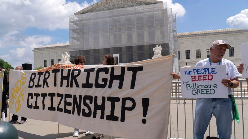
A federal appeals judge on Friday blocked President Donald Trump’s plan to end birthright citizenship for the children of people in the country illegally or temporarily.
U.S. District Judge Leo Sorokin ruled that a nationwide injunction on the Trump administration’s effort to end birthright citizenship that he issued earlier this year and that was granted to more than a dozen states can stand.
Sorokin said the ruling was an exception to a recent U.S. Supreme Court ruling that limited lower courts’ ability to issue nationwide injunctions. The issue is expected to return to the Supreme Court.
Trump and the administration ‘are entitled to pursue their interpretation of the Fourteenth Amendment, and no doubt the Supreme Court will ultimately settle the question,’ Sorokin wrote in his ruling. ‘But in the meantime, for purposes of this lawsuit at this juncture, the Executive Order is unconstitutional.’
The Trump administration has argued that children born in the U.S. to parents in the country illegally and temporarily are not ‘subject to the jurisdiction’ of the United States and therefore not entitled to citizenship.
Trump signed the birthright citizenship executive order, along with a slew of other orders, on his first day in office in January.
On Wednesday, the San Francisco-based 9th Circuit Court of Appeals also affirmed the lower court’s nationwide injunction, and, earlier this month, a New Hampshire federal judge issued a ruling prohibiting Trump’s executive order from taking effect nationwide in a new class-action lawsuit.
Sorokin disagreed with the Trump administration’s argument that the Supreme Court’s ruling warranted a narrower ruling.
The plaintiffs in the class-action lawsuit argued that Trump’s executive order is unconstitutional because the 14th Amendment guarantees birthright citizenship, and it also threatens millions of dollars in state funding for ‘essential’ health insurance services contingent on citizenship status.
Reuters and the Associated Press contributed to this report.
Artist Amy Sherald canceled her upcoming exhibit featuring a portrait of a transgender Statue of Liberty at the Smithsonian’s National Portrait Gallery after Vice President JD Vance raised concerns the show included woke and divisive content, Fox News Digital has learned.
President Donald Trump signed an executive order in March that placed Vance in charge of overseeing the removal of programs or exhibits at Smithsonian museums that ‘degrade shared American values, divide Americans based on race, or promote programs or ideologies inconsistent with Federal law and policy.’
Vance said Sherald’s ‘American Sublime’ exhibit violated Trump’s executive order and was an example of woke and divisive content during a meeting June 9 with the Board of Regents, a source familiar with the meeting told Fox News Digital.
‘Vice President Vance has been leading the effort to eliminate woke indoctrination from our beloved Smithsonian museums,’ an administration official said in an email to Fox News Digital. ‘On top of shepherding the One Big Beautiful Bill through the Senate and helping President Trump navigate international crises, the vice president has demonstrated his ability to get President Trump’s priorities across the finish line.’
Sherald, best known for painting former first lady Michelle Obama’s official portrait in 2018, announced Thursday she was pulling her show, ‘American Sublime,’ from the Smithsonian’s National Portrait Gallery slated for September, The New York Times first reported.
Sherald said she was rescinding her work from the exhibition after being told that the National Portrait Gallery had some concerns about featuring the portrait of the transgender Statue of Liberty during the show. The painting, ‘Trans Forming Liberty,’ depicts a trans woman with pink hair wearing a blue gown.
‘These concerns led to discussions about removing the work from the exhibition,’ Sherald said in a statement, The New York Times first reported Thursday. ‘While no single person is to blame, it’s clear that institutional fear shaped by a broader climate of political hostility toward trans lives played a role.
‘This painting exists to hold space for someone whose humanity has been politicized and disregarded. I cannot in good conscience comply with a culture of censorship, especially when it targets vulnerable communities.
‘At a time when transgender people are being legislated against, silenced and endangered across our nation, silence is not an option,’ Sherald added. ‘I stand by my work. I stand by my sitters. I stand by the truth that all people deserve to be seen — not only in life, but in art.’
The Smithsonian did not immediately respond to a request for comment regarding Vance’s involvement in the matter.
The White House said the removal of Sherald’s exhibit is a ‘principled and necessary step’ toward cultivating unity at institutions like the Smithsonian.
‘The ‘Trans Forming Liberty’ painting, which sought to reinterpret one of our nation’s most sacred symbols through a divisive and ideological lens, fundamentally strayed from the mission and spirit of our national museums,’ Trump special assistant Lindsey Halligan said in a statement to Fox News Digital.
‘The Statue of Liberty is not an abstract canvas for political expression. It is a revered and solemn symbol of freedom, inspiration and national unity that defines the American spirit.’
Other members of the Smithsonian’s Board of Regents include the Chief Justice of the United States, John Roberts, along with senators John Boozman, R-Ark.; Catherine Cortez Masto, D-Nev.; and Gary Peters, D-Mich., along with several other House members.
Fox News’ Gabriel Hays contributed to this report.
The net proceeds raised from the Offering will be used to advance the high-grade El Potrero gold-silver project in Durango, Mexico, and for general working capital.
All securities to be issued will be subject to a four-month hold period from the date of issuance and subject to TSX Venture Exchange approval. The securities offered have not been registered under the United States Securities Act of 1933 , as amended, and may not be offered or sold in the United States absent registration or an applicable exemption from the registration requirements.
About Pinnacle Silver and Gold Corp.
Pinnacle is focused on district-scale exploration for precious metals in the Americas. The high-grade Potrero gold-silver project in Mexico’s Sierra Madre Belt hosts an underexplored low-sulphidation epithermal vein system and provides the potential for near-term production . In the prolific Red Lake District of northwestern Ontario, the Company owns a 100% interest in the past-producing, high-grade Argosy Gold Mine and the adjacent North Birch Project with an eight-kilometre-long target horizon . With a seasoned, highly successful management team and quality projects, Pinnacle Silver and Gold is committed to building long -term , sustainable value for shareholders.
Signed: ‘Robert A. Archer’
President & CEO
For further information contact :
Email: info@pinnaclesilverandgold.com
Tel.: +1 (877) 271-5886 ext. 110
Website: www.pinnaclesilverandgold.com
Neither the TSX Venture Exchange nor the Investment Industry Regulatory Organization of Canada accepts responsibility for the adequacy or accuracy of this release .
Copyright (c) 2025 TheNewswire – All rights reserved.
Here’s a quick recap of some of the most impactful resource sector news items for the week.
The period saw three miners rescued after 60 hours underground at the Red Chris mine in BC, the US announce a mine waste recovery strategy and the Ontario government add C$7 million to boost critical minerals innovation.
Red Chris rescue: Three miners freed after 60 hours underground
Three miners trapped underground at Newmont’s (TSX:NGT,NYSE:NEM) Red Chris copper-gold mine in British Columbia have been safely rescued after more than 60 hours.
The workers were sheltered in a MineARC chamber with access to food, water, and communication, following a series of rockfalls.
The rescue effort, which included drilling a 100-meter access tunnel, concluded successfully, with all miners reported in good health.
We are relieved to share that all three individuals are safe, and in good health and spirits. They had consistent access to food, water, and ventilation whilst they remained in place in a refuge chamber underground over the last two days,” a Newmont statement read. They are now being supported by medical and wellness teams. Their families have been notified.”
Investigations into the cause of the rockfalls are ongoing.
US prioritizes critical mineral recovery from mine waste
The US government is ramping up efforts to recover critical minerals from mine waste, with the Department of the Interior announcing plans to map legacy tailings across federal lands.
The initiative is part of a broader push to secure domestic supplies of essential minerals like lithium, cobalt, and rare earths.
By tapping into existing waste sites, the US hopes to reduce reliance on foreign imports while minimizing new environmental disruptions.
“By streamlining regulations for extracting critical minerals from mine waste, we are unleashing the full potential of America’s mineral resources to bolster national security and economic growth,” said Acting Assistant Secretary of Lands and Minerals Adam Suess. “This proactive approach will attract private investment, support environmental reclamation, and pave the way for mineral independence.”
The move aligns with ongoing federal investment into clean energy and supply chain resilience.
Zijin leads bid for Barrick’s Tongon mine in West Africa
Chinese mining giant Zijin Mining Group (OTC Pink:ZIJMF,HKEX:2899,SHA:601899) is reportedly leading the race to acquire Barrick Mining’s (TSX:ABX,NYSE:B) Tongon gold mine in Côte d’Ivoire.
Barrick has tapped TD Securities and Australia-based Treadstone Resource Partners to advise on the sale of Tongon. The operation produced 148,000 ounces of gold in 2024.
With resources depleting, the mine is expected to enter care and maintenance by 2027.
Sources say the bid could be valued near US$500 million as Barrick shifts its focus toward copper and lithium assets.
The potential deal signals ongoing Chinese interest in African gold assets and underscores Barrick’s strategic pivot toward energy transition materials.
No final agreement has been announced.
Panther Minerals exits Boulder Creek uranium project in Alaska
Panther Minerals (CSE:PURR,OTC:GLIOF,FWB:2BC) has officially ended its option to acquire the Boulder Creek uranium project in Alaska’s Cape Nome District.
The company chose not to proceed with its next annual payment, leading to the automatic termination of the agreement signed in April 2024.
All 140 associated mining claims have been returned to Tubutulik Mining Company LLC via a quitclaim deed.
While Panther completed preliminary assessments and a site review, it opted not to advance the project further, citing seasonal, logistical, and capital constraints.
The project had drawn criticism from local Indigenous groups concerned about environmental impacts.
Ontario adds C$7 million to Critical Minerals Innovation Fund
The Ontario government is committing over C$7 million to expand its Critical Minerals Innovation Fund (CMIF), aiming to boost research, development and commercialization across the province’s mining sector.
The new funding round—open for applications from July 23 to October 1—targets innovation in deep exploration, mineral recovery, battery supply chains and mining technologies.
This latest investment brings total CMIF funding to C$27 million since its 2022 launch, supporting more than two dozen projects to date.
The CIMF also aligns with Ontario’s broader Critical Minerals Strategy, which seeks to strengthen domestic supply chains and reduce reliance on foreign sources, especially amid growing global demand and looming US tariffs.
“With global demand for critical minerals soaring – and new US tariffs targeting Canada’s mining and manufacturing sectors – Ontario is taking action to accelerate growth and innovation in Ontario’s mining sector,’ said Stephen Lecce, Minister of Energy and Mines.
He added: “Through the Critical Minerals Innovation Fund, we are putting Ontario first, building a made-in-Canada supply chain that attracts investment and creates good-paying jobs here at home.”
Looking down the supply chain, the Ontario government is also investing C$500 million in the creation of a new Critical Minerals Processing Fund to “provide financial support for projects that accelerate the province’s critical mineral processing capacity and made-in-Ontario critical minerals supply chain.”
Securities Disclosure: I, Georgia Williams, hold no direct investment interest in any company mentioned in this article.
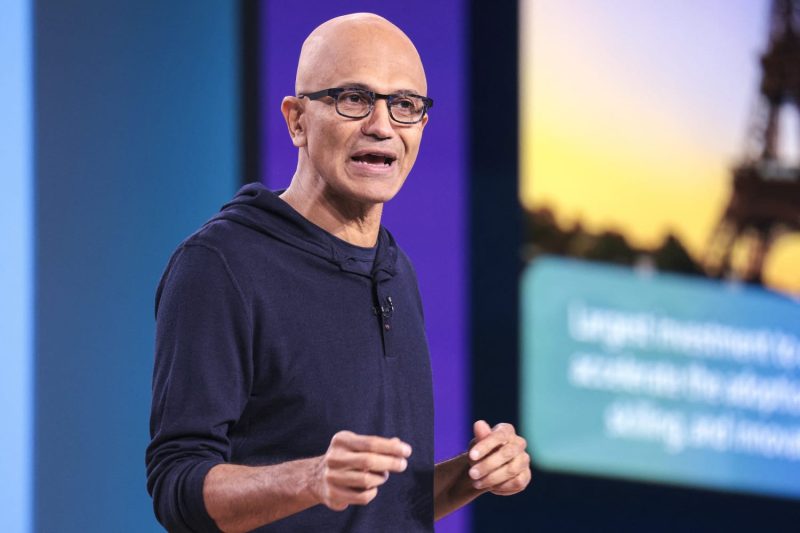
Microsoft has laid off over 15,000 people so far in 2025. The stress of the belt-tightening has gotten to CEO Satya Nadella.
“Before anything else, I want to speak to what’s been weighing heavily on me, and what I know many of you are thinking about: the recent job eliminations,” Nadella wrote in a memo to employees Thursday.
After Microsoft’s latest labor reductions, investors pushed the stock’s closing price above $500 for the first time on July 9. The company announced the layoffs of about 9,000 people a week earlier. Microsoft employed 228,000 people as of June 2024. It hasn’t provided a new figure that takes into account its layoffs this year, but Nadella wrote that headcount is basically flat.
“This is the enigma of success in an industry that has no franchise value,” he wrote. “Progress isn’t linear. It’s dynamic, sometimes dissonant, and always demanding. But it’s also a new opportunity for us to shape, lead through, and have greater impact than ever before.”
The cuts at Microsoft are reflective of an overall trend across the tech industry, with over 80,000 positions eliminated to date in 2025, according to one count. Recruit Holdings announced earlier this month that it would lay off 1,300 people from its human resources technology segment that includes the Indeed and Glassdoor websites. The company’s CEO pointed to artificial intelligence in a memo, Bloomberg reported.
On social media in recent months, some Microsoft employees have become disheartened about the company’s cutbacks, given its stature.
“I have loved working for this company, still do, but this has done so much damage to that loyalty because it has shown that Microsoft’s espoused values do not apply to business decisions at the macro level,” a person who lists themselves as a Microsoft directed on LinkedIn posted last week.
Microsoft is the world’s most valuable public company after Nvidia, whose chips have become a critical piece of the AI arms race. Microsoft’s Windows and Office franchises remain dominant, and its Azure cloud services have seen faster growth in recent years as OpenAI and other companies rent out Nvidia graphics cards to run AI models.
In the memo, Nadella touched on Microsoft’s mission for the past 10 years, which has been to empower every person and every organization on the planet to achieve more, and how the rise of AI is changing it.
“We must reimagine our mission for a new era,” he wrote. “What does empowerment look like in the era of AI? It’s not just about building tools for specific roles or tasks. It’s about building tools that empower everyone to create their own tools. That’s the shift we are driving — from a software factory to an intelligence engine empowering every person and organization to build whatever they need to achieve.”
Trump administration regulators have approved Skydance Media’s $8 billion bid to acquire CBS News parent company Paramount, paving the way for a tectonic shift in ownership of one of America’s three major networks.
The Federal Communications Commission said Thursday that it had approved the acquisition, with FCC Chairman Brendan Carr adding in a news release that the move would bring change to the company’s news coverage. Paramount owns CBS, which includes CBS News.
‘Americans no longer trust the legacy national news media to report fully, accurately, and fairly. It is time for a change,’ Carr said. ‘That is why I welcome Skydance’s commitment to make significant changes at the once storied CBS broadcast network. In particular, Skydance has made written commitments to ensure that the new company’s programming embodies a diversity of viewpoints from across the political and ideological spectrum.’
‘Today’s decision also marks another step forward in the FCC’s efforts to eliminate invidious forms of DEI discrimination,’ Carr added.
David Ellison; Shari Redstone.AP; Getty Images
In recent days, Paramount’s new owner made a number of concessions to the FCC, including agreeing to not implement any diversity, equity or inclusion programs. Skydance also said it would ‘undertake a comprehensive review’ of CBS and ‘will commit, for a period of at least two years, to have in place an ombudsman.’ That role would report to the president of the new company.
A number of companies that have billion-dollar transactions pending before Carr’s FCC have also backed off of DEI programs, including Verizon and T-Mobile.
The concessions also came after Paramount Global settled a lawsuit with President Donald Trump for $16 million. Trump brought that suit, saying the way CBS edited a ’60 Minutes’ interview with former Vice President Kamala Harris was ‘election and voter interference.’
The lone Democrat in FCC leadership, Commissioner Anna Gomez, did not mince words about the push to secure promises from the companies.
“After months of cowardly capitulation to this Administration, Paramount finally got what it wanted,’ she said in an emailed statement.
‘In an unprecedented move, this once-independent FCC used its vast power to pressure Paramount to broker a private legal settlement and further erode press freedom,’ she added. ‘Once again, this agency is undermining legitimate efforts to combat discrimination and expand opportunity by overstepping its authority and intervening in employment matters reserved for other government entities with proper jurisdiction on these issues.’
‘Even more alarming, it is now imposing never-before-seen controls over newsroom decisions and editorial judgment, in direct violation of the First Amendment and the law.’
Skydance is run by David Ellison, son of Oracle founder and Trump ally Larry Ellison. While the younger Ellison made a donation to President Joe Biden’s re-election fund in February 2024 shortly before the former president bowed out of the race, Trump recently signaled his comfort with his takeover of Paramount and its assets, which in addition to CBS News include Nickelodeon, Comedy Central, The CW, MTV, BET and film franchises like “Smurfs” and “Sonic the Hedgehog.”
“Ellison is great. He’ll do a great job with it,” Trump said in June.
There is likely to be a sea change in the editorial direction of CBS News under its new ownership. In a recent filing, Ellison and Skydance said they’d told Carr that they were committed to pursuing a focus on “American storytelling” while touting a new, “unbiased” editorial direction for CBS News. Their meeting came shortly after Paramount agreed to settle Trump’s lawsuit.
It also came just days after CBS announced it was canceling “The Late Show,” currently hosted by Stephen Colbert — an announcement Trump praised on social media. Colbert had recently criticized the parent company’s multimillion-dollar settlement with Trump, while CBS said the cancellation was “purely a financial decision against a challenging backdrop in late night.”
There had been signs of an editorial shift ahead of the merger. Most notably, longtime “60 Minutes” editor Bill Owens announced he was stepping down this spring, citing CBS News’ fading editorial independence. Shortly after, CBS News President and CEO Wendy McMahon was pushed out. Last week, The New York Times reported Skydance was in early talks to acquire the conservative-leaning The Free Press media outlet. Meanwhile, “Daily Show” host Jon Stewart has said he did not know whether his program would survive the merger.
Skydance has spent years pursuing Paramount and eventually realized it could successfully execute the transaction by purchasing Paramount’s parent, National Amusements, the company once helmed by Sumner Redstone, the father of the company’s current chairwoman, president and CEO, Shari Redstone. Yet the proposed deal continued to face hurdles, first under the Biden administration then at the outset of Trump’s term. Its approval came in what was its third deadline extension period.
Teck Resources (TSX:TECK.A,TSX:TECK.B,NYSE:TECK) has secured board approval for a multi-billion-dollar life extension of its Highland Valley copper mine in British Columbia, setting the stage for a two-decade boost in copper output.
The Vancouver-based miner said Thursday (July 24) that construction on the Highland Valley Copper Mine Life Extension Project (HVC MLE) will begin in August, following receipt of environmental and permitting approvals in June.
The newly sanctioned Highland Valley project is expected to extend the mine’s life from 2028 through 2046, with average annual copper production of 132,000 metric tons.
The company further confirmed that engineering progress is nearly 70 percent complete.
Over its lifespan, the project is expected to maintain approximately 1,500 direct jobs and US$500 million in annual GDP from current operations. During the construction phase alone, Teck said that it anticipates roughly 2,900 jobs and US$435 million in additional GDP.
“This extension of Canada’s largest copper mine, Highland Valley, is foundational to our strategy to double copper production,” said CEO Jonathan Price in the company’s announcement.
“The project will strengthen Canada’s critical minerals sector, generate new economic activity, and support the continuation of the jobs and community benefits that HVC generates for many more years to come,” Price added.
The announcement comes as Teck posted better-than-expected earnings for the second quarter. The company reported an adjusted profit of C$0.38 per share, beating the average analyst estimate of C$0.27.
The outperformance was largely attributed to stronger profitability from the company’s Trail operations, a major zinc and lead smelting complex also located in British Columbia.
Teck produced 109,100 metric tons of copper in the quarter ending June 30 but lowered its full-year copper production guidance to a range of 470,000 to 525,000 metric tons, down from earlier estimates.
While London Metal Exchange (LME) copper prices dipped 2 percent year-over-year to an average of US$4.32 per pound during the quarter, Teck could benefit from recent geopolitical developments that may tighten global copper supply.
US President Donald Trump’s planned 50 percent copper import tariff, set to take effect August 1, could push prices higher despite Teck’s minimal exposure to the US market, as most of the company’s copper exports go to Asia and Europe.
The company said that it expects the project’s total ore throughput to average 50 million metric tons annually, while total material moved will vary significantly depending on the phase.
Securities Disclosure: I, Giann Liguid, hold no direct investment interest in any company mentioned in this article.
The Pentagon has suspended participation in all think tank events until further notice, departing from a history of dialogue with Washington’s civilian national security realm.
The move is an attempt ‘to ensure the Department of Defense is not lending its name and credibility to organizations, forums and events that run counter to the values of this administration.’
‘Going forward, no DOD official will attend events by America Last organizations that promote globalism and hate (President Donald Trump),’ Pentagon press secretary Kingsley Wilson wrote on X.
In the future, the Defense Department (DOD)’s Office of Public Affairs will conduct a ‘thorough vetting’ every time an official is invited to a conference to decide whether the event advances Trump’s agenda.
Such security events often are funded by foreign governments or defense contractors and serve as a space for such players to push a message or a product they sell to key officials and for defense officials to put out a message of their own from the U.S. government.
The move comes after the Pentagon yanked its officials from participation in the Aspen Security Forum — a gathering of defense-minded industry leaders and researchers.
Wilson had said the secretary’s office believed that event ‘promotes the evil of globalism, disdain for our great country, and hatred for the President of the United States.’
Several top military officials had been scheduled to speak at the event.
Historically, defense secretaries have participated in defense conferences and think tank events like the Munich Security Conference or the Reagan Defense Forum.
Hegseth skipped out on the Munich Security Conference but attended the International Institute of Strategic Studies (IISS) Shangri-La Dialogue in Singapore in May.
Aspen previously told Fox News Digital, ‘For more than a decade, the Aspen Security Forum has welcomed senior officials – Republican and Democrat, civilian and military – as well as senior foreign officials and experts, who bring experience and diverse perspectives on matters of national security. We will miss the participation of the Pentagon, but our invitations remain open.’
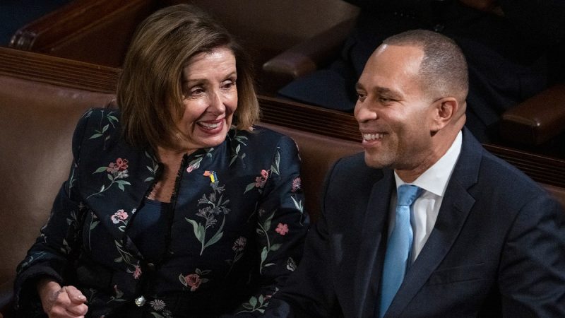
Former House Speaker Nancy Pelosi, D-Calif., exuded confidence as she declared to Gen Z activists at the Voters of Tomorrow summit that the Democrats would take back the House in 2026.
‘We have no doubt that we will win the election with the House of Representatives,’ Pelosi said, eliciting applause from the crowd. She then responded to the cheers by once again saying ‘No doubt.’
The longtime California lawmaker also said she was confident that House Minority Leader Hakeem Jeffries, D-N.Y., would be speaker of the House after the 2026 midterms.
While Pelosi was confident about the Democrats’ chances, she also emphasized the need for preparation. The former House speaker credited early preparation for the Democrats’ victories in 2006 and 2018 to early preparation, saying that 2026 could be the same.
‘It’s important to be strong in the year in advance, because that’s when the troops line up. We have our messaging, we have our mobilization, we need the money to do it, but they go only next to a school to hold up the most important part: the candidate,’ she said.
However, Pelosi sees another element as being key to Democrats’ victory: bringing down President Donald Trump’s approval rating. The former House speaker called Trump’s current numbers ‘terrible.’
‘By October — certainly by November, but by October, we will have — with the help of so many people working — we’ll have taken what’s his name’s numbers down,’ Pelosi said.
A recent Fox News Poll found that 46% of voters approve of Trump’s performance, while 54% disapprove. That’s exactly where things stood last month, and better than at this point 8 years ago when 41% approved.
The Voters of Tomorrow summit boasts a lineup of high-profile speakers alongside Pelosi, including former Vice President Kamala Harris, Rep. Ro Khanna, D-Calif., Rep. Jamie Raskin, D-Md., and David Hogg. Both Harris and Raskin are set to address the group virtually.
Fox News’ Dana Blanton and Victoria Balara contributed to this report.